viewers

Sunday, 8 June 2014

NEBULA

Nebula

nebula (from Latin: "cloud") is an interstellar cloud of dusthydrogenhelium and other ionized gases. Originally,nebula was a name for any diffuse astronomical object, including galaxies beyond the Milky Way. The Andromeda Galaxy, for instance, was referred to as the Andromeda Nebula (and spiral galaxies in general as "spiral nebulae") before the true nature of galaxies was confirmed in the early 20th century by Vesto SlipherEdwin Hubble and others. Nebulae are often star-forming regions, such as in the Eagle Nebula. This nebula is depicted in one of NASA's most famous images, the "Pillars of Creation". In these regions the formations of gas, dust, and other materials "clump" together to form larger masses, which attract further matter, and eventually will become massive enough to form stars. The remaining materials are then believed to form planets, and other planetary system objects.

Here are some few photos

The Cat's Eye Nebula

Carina Nebula
(
ESO - http://www.eso.org/public/images/eso0905a/
Colour-composite image of the Keyhole, a dark nebula within the Carina Nebula.)

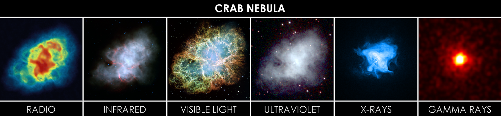
The Crab Nebula
(by Torres997 Radio: NRAO/AUI and M. Bietenholz; NRAO/AUI and J.M. Uson, T.J. Cornwell Infrared: NASA/JPL-Caltech/R. Gehrz (University of Minnesota) Visible: NASA, ESA, J. Hester and A. Loll (Arizona State University) Ultraviolet: NASA/Swift/E. Hoversten, PSU X-ray: NASA/CXC/SAO/F.Seward et al. Gamma: NASA/DOE/Fermi LAT/R. Buehler -Radio: http://images.nrao.edu/393http://images.nrao.edu/34 (Very Large Array{{NRAO}}: CC-by-3.0) Infrared:http://www.nasa.gov/multimedia/imagegallery/image_feature_567.html (Spitzer{{PD-USGov-NASA}}: Public domain) Visible:http://hubblesite.org/newscenter/archive/releases/2005/37/image/a/ (Hubble{{PD-Hubble}}: Public domain) Ultraviolet:http://www.nasa.gov/mission_pages/swift/bursts/swift-images.html (Swift{{PD-USGov-NASA}}: Public domain) X-ray:http://chandra.harvard.edu/photo/2008/crab/ (Chandra{{PD-USGov-NASA}}: Public domain) Gamma: http://svs.gsfc.nasa.gov/cgi-bin/details.cgi?aid=10767 (Fermi{{PD-USGov-NASA}}: Public domain))

The delicate shell

The Horsehead Nebula

HH 46/47 are small patches of nebulosity associated with newly born stars[

Herbig-Haro


 diffuse nebula

The "Pillars of Creation" from the Eagle Nebula.

 The Flame Nebula

The Triangulum Emission Garren Nebula

The Omega Nebula

The Red Rectangle Nebula


Eagle nebula pillars

Portion of the Carina nebula


References : http://en.wikipedia.org/wiki/Nebula

Monday, 26 May 2014

Kyrgyzstan

Kyrgyzstan


Fast Facts
Capital: Bishkek
Population: 5,550,239 (2010)
Area: 199,900 km2
Currency: Kyrgyzstani som
Official Language: Russian, Kyrgyz
Calling Code: +996
Government: Presidential system, Republic, Parliamentary republic

1. World's biggest walnut forests

walnut forest

Who knew Kyrgyzstan has the world’s largest remaining stands of walnut-fruit forests ? Heading west from Jalalabad in southern Kyrgyzstan -- no relation to the eponymous metropolis in eastern Afghanistan -- you’ll see walnuts growing alongside apples, pistachios and other crops suited to the dry climate.
From 1995 to 2010, the Swiss government attempted to help Kyrgyzstan reform its Soviet-designed forestry sector. Experts familiar with the “collaborative forest management” initiative say the results in Kyrgyzstan’s walnut-fruit forests have been, well, mixed. 

2. Osh -- bazaar 


At Osh bazaar, one can buy food products, almost any common household good, clothes, Kyrgyzstan souvenirs, and even musical instruments. Kyrgyz national clothes, which are sold in the national goods section, are mostly sewn at the bazaar at a sewer's guild named "Kyyal" (KyrgyzКыял - "fantasy/dream"), and may be special ordered (for size, colour, etc.) through the bazaar vendors.

3. Home to a super-old tower


Kyrgyzstan’s Burana Tower, which historians say dates to the 10th century, was a lookout for the city of Balasagyn, one of the largest medieval cities in the visually stunning Chui Valley. Fortunately Genghis Khan’s Mongols opted not to destroy the tower when they later stormed through the area.
Be sure to climb the 25-meter-high tower’s cramped interior staircase and enjoy the panoramic view.

4. Lake Issyk kul.


An interesting fact about Lake Issyk Kul, meaning "warm sea", is that it never ever freezes, in spite of being sited in the mountains.

5. Fergana Valley.


Osh city of Kyrgyzstan, sited in the Fergana Valley, is said to be three thousand years old. Fergana Valley has been known for its legendary horses, since the ancient times. Fergana Valley was the birthplace of Akhmed Al Fergani, the famous astronomer from medieval times.

6. Kyrgyzstan Tea.


Common types of bread  available in Kyrgyzstan include Central Asian flat bread, and thick, sturdy Russian breads. Central Asian flat bread is cooked over coals in tandoori ovens, and is round and relatively flat.
More traditional bread products include qattama and boorsoq, two types of fried bread.
The Kyrgyz often eat various breads by dipping it in jam, qaymaq, butter,etc. Boorsoq is sometimes eaten suspended in tea, or dipped in honey.
Bread is valued as sacred in Kyrgyz culture, and a good host always offers a guest bread at the very least (often with tea), even if the guest is only staying for a few moments.

Sunday, 25 May 2014

TAJIKISTAN

Fast Facts about Tajikistan


Continent: Asia
Area: 143,100 km2
Capital: Dushanbe
Population: 7,616,000
Official Languages: Tajik (Persian) and Russian
Independence Day: September 9, 1991
Type Of Government: Unitary semi-presidential republic
 
Fun & Interesting Facts About Tajikistan
  • The official name of Tajikistan is the ‘Republic of Tajikistan’.
  • The official language of Tajikistan is Tajik, though Dari, Russian and Uzbek are also spoken there.
  • Majority of the population in Tajikistan comprises of Sunni Muslims, followed by Shiite Muslims and Christians.
  • The largest ethnic group in Tajikistan comprises of Tajiks.
  • The currency of Tajikistan is Somoni.


  • The capital of Tajikistan is Dushanbe.
  • Tajikistan follows the system of Unitary Presidential Republic.
  • Tajikistan was initially a part of the Samanid Empire, but was created as an Autonomous Soviet Socialist Republic, within Uzbekistan, in 1924.
  • Tajikistan was separated from Uzbekistan in 1929 and became a Soviet Socialist Republic.
  • Tajikistan became an independent nation in 1991, after the dissolution of USSR.
  • Tajikistan suffered from a devastating civil war in the late 20th century, which lasted from 1992 to 1997.
  • The ancient city of Khodjand, located in Tajikistan, was an important location on the Silk Route Road.
  • Tajikistan established diplomatic ties with China in 1992, and since then, the two countries’ friendly-relations have helped each other’s economies grow.
  • The terms ‘Tajikistan’ literally means ‘Land of the Tajiks’.
  • ‘Ismoili Somoni’ (7,495 m) forms the highest point in Tajikistan.
  • The Iskanderkul Lake of Tajikistan is named after Alexander the Great.


  • Fergana Valley is an area that is shared by Tajikistan, with Uzbekistan and Kyrgyzstan.

Fergana Valley


  • Sarazm, near Penjikent, is a settlement that was in existence in the Bronze Age.
  • The ‘Silk Road’, forming a major trade route between China and Europe, passed through Tajikistan.
  • Did you know Russian soldiers are reported to have seen the Abominable Snowman or the ‘Yeti’ in the Pamir Mountain ranges. The legend of the Yeti still exists in Tajikistan today.

yeti


  • Karabair and Lokai horses are reared in Tajikistan.
lokai
karabair


  • Tajikistan consists of 4 administrative divisions: provinces of Sughd and Khatlon, the autonomous province of Gorno-Badakhshan (GBAO) and the Region of Republican Subordination.
  • Tajikistan is amongst the smallest nations in Central Asia, in terms of area.
  • More than fifty percent of Tajikistan land is over 3,000 meters (approx. 10,000 ft.) above sea level.
  • Over ninety percent of the area in Tajikistan is mountainous.
  • Aluminum, zinc, lead, chemicals and fertilizers make up the major industries of Tajikistan.
  • More than 80% of the Tajik population is Sunni Muslims. 5% are Shi’a Muslims and the remaining 15% comprise of the other religions.
  • Lake Karakul is located in the Pamir Mountain Range and is 3915 meters above sea level.
  • Ismoili Somoni was a popular ruler of the Tajiks at the beginning of the 10th century. Today, one of the highest mountain points in Tajikistan is named after him

Reference:http://lifestyle.iloveindia.com/lounge/facts-about-tajikistan-2419.html

Friday, 16 May 2014

PEGADINHA: Menina Abandonada (Abandoned Child Prank)


Mars


Description:

Mass: 641,693,000,000,000 billion kg (0.107 x Earth)
Equatorial Diameter: 6,805
Polar Diameter: 6,755
Equatorial Circumference: 21,297 km
Known Satellites: 2
Notable Satellites: Phobos & Deimos
Orbit Distance: 227,943,824 km (1.38 AU)
Orbit Period: 686.98 Earth days (1.88 Earth years)
Surface Temperature: -87 to -5 °C
First Record: 2nd millennium BC
Recorded By: Egyptian astronomers

Facts

1.       Mars and earth have  approximately the same landmass : even though mars has only 15% of the earth’s volume & just over 10% of the earth mass, around two third of the earth’s surface is covered in water martin surface gravity is only 37% of earths ( meaning you can leap three times higher on mars).


2.       Mars is the home to the tallest mountain in the solar system. : Olympus Mons, a shield volcano, is 21 km high and 600 km in diameter. Despite having formed over billions of years, evidence from volcanic lava flows is so resent many scientists believe it could still be active.


3.       Mars has polar caps like Earth, although  mars polar caps contain mostly frozen carbon dioxide instead of frozen water


4.       Mars is believed to have had water flowing around it like Earth once. It may have had a blue sky too. However, it is unlikely that it had grass trees and plants like earth has now.


5.       Mars has seasons like Earth. This is caused by the tilt of the planet’s axis, at a similar angle to the tilt of earth’s axis.


6.       The Sun appears about half the size on mars as it does from Earth.


Wednesday, 14 May 2014

Brazil

  1. Brazil’s official name isRepública Federativa do Brasil(Federative Republic of Brazil).o
  2. The word “Brazil,” meaning “red like an ember,” comes frompau brasil (brazilwood), a tree that once grew abundantly along the Brazilian coast that produced a deep, red dye. Brazilwood was valued by European traders who came from the Portuguese coasts in the 16th century to trade with the Tupí-Guaraní Indians.h
  3. Brazil FactsBrazil has 4,655 miles (7,491 km) of coastline
  4. Brazil has 4,655 miles (7,491 km) of coastline, making it the longest continuous coastline in the world.o
  5. The Portuguese officially named what we now know as Brazil Terra do Santa Cruz (Land of the Holy Cross), but traders simply called it Terra do Brasil.h
  6. Brazil is the fifth largest country by landmass in the world with 5.35 million square miles (8.45 million square km). It is the largest country in both South America and the entire Latin American region.o
  7. The highest point in Brazil is Pico da Neblina at 9,823 feet (2,994 m).o
  8. Brazil is the largest Lusophone (Portuguese-speaking) nation in the world and the only one in the Americas.a
  9. Brazil is the sixth largest country in the world by population at 201,009,622 people.o
  10. Brazil’s official birthday as a country occurred on September 7, 1822, when Prince Pedro refused to return to Portugal. He announced the Grito de Ipiranga by throwing down his sword and shouting, “Independence or death!” Although free of Portugal’s hold, Brazil remained a monarchy until its declaration of independence as a republic in 1889.n
  11. Flag of BrazilBrazil’s national flag was officially adopted on November 19, 1889
  12. On Brazil’s modern flag, the green represents the forests of Brazil, the yellow rhombus reflects its mineral wealth, and the blue circle and stars depict the sky over Rio de Janeiro on the morning of November 15, 1889, when Brazil declared itself a republic.o
  13. Elected on October 30, 2010, Dilma Rousseff is Brazil’s current president and the first woman to hold this office.d
  14. Brazil is the world’s largest market for crack cocaine.f
  15. Brazilian cowboys are called gaúchos. They live primarily in Rio Grande do Sul in the southern part of the country, which is part of the South American pampas and borders Uruguay and Argentina.g
  16. The Amazon River, over half of which lies within Brazil, is the world’s largest by volume. It is 3,977 miles (6,400 km) long and during the wet season it can become over 118 miles (190 km) wide.o
  17. Natives of Rio de Janeiro’s city proper are called Cariocas.a

References

http://facts.randomhistory.com/brazil-facts.html